- Преподавателю
- Иностранные языки
- Ағылшын тілі пәнінен «Елтану» арнайы курсының бағдарламасы 5-6 сыныптарға арналған
Ағылшын тілі пәнінен «Елтану» арнайы курсының бағдарламасы 5-6 сыныптарға арналған
| Раздел | Иностранные языки |
| Класс | - |
| Тип | Рабочие программы |
| Автор | Смагулова А.С. |
| Дата | 18.12.2014 |
| Формат | docx |
| Изображения | Есть |

 Kazakhstan
Animals and plants of Kazakhstan
All across the 1800 km-long «vertical line» that separates southern and northern confines of Kazakhstan one landscape zone replaces another: forest-and-steppe, steppe, semi-desert and desert ones. In the West, the territory of Kazakhstan shares its border with the Caspian Sea, in the East, it is the Altay taiga that lines the Republic and high peaks of Tien-Shan constitute the border of the country in the South. The lowest point the Karaghie depression (132 m below sea level) is situated on the Manghystau peninsula while the highest one is Khan Tengri peak in Tien-Shan mountains (about 7,000 m over sea level). Three major rivers - Yertys, Tobol and Ishim flow into the Arctic Ocean while the rest of the streams either fall into land-locked reservoirs (Caspian and Aral seas, the lake of Balkhash) or just get lost in the vast steppe or desert ranges. It is in fact the main feature of Kazakhstan as a geographic region. The second peculiarity consists in a certain asymmetry of landscapes: its western portion (to the West of the 68 E.L. meridian) is almost exclusively plain like, whereas the eastern one is predominantly mountainous. Apart from such high mountains as Tien-Shan and Altay quite sizable portion of territory is occupied by Tarbagatay, Saur, Kazak low hills, Kokshetau height.
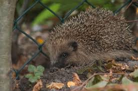
In Kazakhstan there grow over 6,000 species of plants (of which 535 grow only here) and on its vast space one can come across almost 500 species of birds, animals (178 spcs), reptiles (49 spcs), amphibia (12 spcs), fish (107 spcs). The host of the invertebrate is ever greater: insects only number some 30,000 species.
The Usturt plateau situated between the Caspian and Aral seas is a slightly hilly desert-like plain, here and there grown with wormwood and unprepossessing shrubs of Russian thistle. Only in wide-spread drainless depressions there occur shrubs of black saxaul. Steep ledges (chinks) add immensely to the inimitable beauty of the landscape.
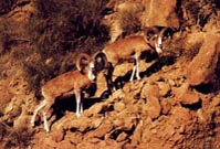
Particularly picturesque is the Western chink whose height attains 340 m: its eroded precipice would, time and again, take quite fanciful forms. The area is inhabited by such rare animals as Usturt moufflon or urial, ratel from the family of martens, long-needled hedge-hog and a good many species of wild cats: karakal, barhkan cat and the famous cheetah. No small is the number of slim gazelles-Zairians, beautiful bustards (or Jacks) and such other birds of desert.
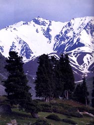
Slopes of Northern Tien-Shan are covered with fir-woods while those of the West are grown with scarce arches trees eventually intermingled with high-grass waterless valleys. Here the gorges are grown with apple-trees and other nut-and-fruit trees. High up in the sky one can see mountainous peaks covered with permafrost snows and glaciers.
It's only here that one can come across a frightful snow leopard (irbis), Tien-Shan brown bear, Siberian stag. The «feathered world» is represented by the famous bearded vulture whose wing-span is up to over 3 m, a Himalaiyan ular or mountain turkey-hen, a snow griffon-vulture, a white-headed vulture, a golden eagle (the favourite bird of Kazak hunters), an Alpine finch and fairly-like blue bird-Alpine jackdaw…
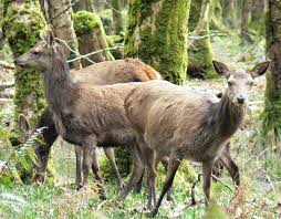
If you happen to visit taiga-grow mountains of the Altay you might come across a giant of an elik, a handsome Siberian stag, our smallest deer- a musk-deer («kabyrga»), the famous sable and gracefully handsome chipmunk.
Only here one can find a wood-grouse, a hazel-grouse, a willow grouse and a ptarmigan. Small wonder that the national authorities have turned the Alpine lake Markakol in South Altay into a special reserve to protect the local flora and fauna. The lake hosts a good many waterfowl whereas its banks and the woods serve a fine nestling place for such rare birds as fishhawk and black stork.
As to the Alpine heights they are inhabited by an exceedingly rare bird species - the Altay ular.
Steppes of Kazakhstan are no second in beauty to other landscape zones. They gain particular fascination because of sweet-and salt-water lakes which attract thousands of waterfowl represented by dozens of species of ducks, geese, gulls, herons, sandpipers, roseate terns. The salt-water lake of Tenghiz situated in Central Kazakhstan has been turned into a Kurgaldzhy reserve for it is only here thatpink flamingos make their nests (in fact it is their northernmost colony!). Another, Naurzum steppe reserve is just as rich with various fowl. Apart from a numerous lakes one can admire here a unique pine forest, the southernmost in Kazak steppes. Quite a number of prey-birds have chosen the area for nestling: imperial eagles, falcons (balobans, merlins, common kestrels and others).
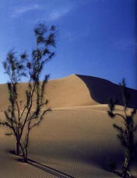
Deserts too display no small specifics. For the most part they are represented by vast argillaceous plains grown with wormwood and Russian thistle. Along with the aforementioned Usturt, the world-famous Betpak-Dala ranging from the lake of Balkhash to the rivers of Shu and Sarysu adds much to the peculiar fascination of the area. Sand deserts in Kazakstan are represented by such tracts of sand as Kyzylkum (to the West of Syrdaria river), Muyunkum (to the South of Betpak-Dala and Shu river), by sands of South Transbalkhash territory (Sarytaukum, Saryishikatyrau, etc), Transaral Karakum. Most often the barkhans are covered with saxaul, zhuzghun, sand acacia. The area is inhabited by Middle Asian gazelles ousted to the sands by common sheep, many species of jerboas, polecats, piebald poutorak, steppe wiesel and by several species of birds: saxaul jays, steppe hens, larks, desert doves.
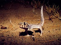
Yet most characteristic of the desert fauna are, no doubt, reptiles: Middle Asian tortoise, the world largest lizard - grey monitor lizard (its habitat is the desert of Kyzylkum only), steppe agama, several species of geckos, round-headed lizards, small lizards and 17 species of snakes.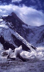
Astana
Astana (the former Akmola) was founded in 1830 as a fortification of Russian Empire. In 1862 stanitsa Ak-mola got the status of a town. In the course of time Akmola became the centre of trade fairs where merchants from all over Kazakhstan. Russia, Central Asia, India and other countries gathered to sell cattle and agricultural products. For a long time Akmola was an outpost of Russian Empire seeking the way to developed trade and its political influence upon Central Asia in XVIII-XIX centuries. With the growth of anti - tsarist and revolutionary public mood the Akmloa prison became over crowed with those who wanted freedom. In March 1917 the Soviet Power was established in Akmola.
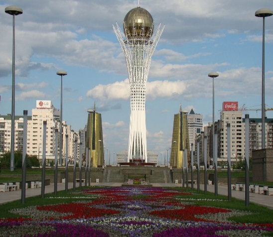
Many changes have taken place since then. Akmola played an important role in supplying the Soviet Army with raw materials and products during the Second World War. In 1961 Akmola was renamed into Tselinograd and became the centre of Tselinny Krai. In 1992 the city got its name Akmola again and sice October 1997 Akmola has become a new capital of the Republic of Kazakhstan. Later on it got its present name Astana. Astana is a modern growing city, a political, financial, economic, scientific and socio-cultural centre of the state. There are a lot of magnificent beautiful buildings, higher educational establishments, colleges and secondary schools, hotels, banks and other commercial structures in Astana, the new capital of the Republic of Kazakhstan. There are many places of interest in Astana: the Central Square the Republic Avenue, the Palace of Youth and the Bridge across the Ishim River, the Reginal Museum of Fine Arts and others. From everywhere you can see Baiterek, the symbol of prosperity and happiness.
Astana formerly known as Akmola until 1998, Tselinograd until 1992 and Akmolinsk until 1961, has been the capital of Kazakhstan since 1997, and is the country's second largest city (after Almaty, the former capital) with an officially estimated population of 814,401 as of 1 January 2014. It is located in the north portion of Kazakhstan, within Akmola Province, though administrated separately from the province as a federal city area.
Geography and climate
Astana is located in central Kazakhstan on the Ishim River in a very flat, semi-arid steppe region which covers most of the country's territory. The elevation of Astana is 347 m (1,138 ft) above sea level. Astana is in a spacious steppe landscape, in the transitional area between the north of Kazakhstan and the extremely thinly settled national center, because of the river Ishim. The older boroughs lie north of the river, whilst the new boroughs are located south of the Ishim. Astana is the second coldest capital city in the world after Ulaanbaatar, Mongolia, a position formerly held by Canada's capital, Ottawa, until Astana attained capital city status in 1998. Astana has an extreme continental climate with warm summers (featuring occasional brief rain showers) and long, very cold, dry winters. Summer temperatures occasionally reach 35 °C (95 °F) while −30 to −35 °C (−22 to −31 °F) is not unusual between mid-December and early March. The city also holds the record for the lowest air temperature ever recorded in Kazakhstan (-51 °C). Typically, the city's river freezes over between the second week of November and the beginning of April. Astana has a well-deserved reputation among Kazakhstanis for its frequent high winds, the effects of which are felt particularly strongly on the fast-developing but relatively exposed Left Bank area of the city.
Almaty
Almaty pronounced [ɑl.mɑ.ˈtə]), formerly known as Alma-Ata and Verniy is the largest city in Kazakhstan, and was the country's capital until 1997. Despite losing its status as the capital to Astana, Almaty remains the major commercial and cultural centre of Kazakhstan, as well as its largest population center. The city is located in the mountainous area of southern Kazakhstan.The climate in Almaty is a humid continental climate with hot summers and cold winters. It is characterized by the influence of mountain-valley circulation, which is especially evident in the northern part of the city, located directly in the transition zone of the mountain slopes to the plains.
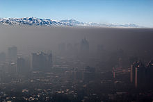

Smog over Almaty
Annual average air temperature is equal to 10 °C (50 °F), the coldest month is January, −4.7 °C (24 °F) (on average), the warmest month (July) 23.8 °C (75 °F) (on average). In average years frost starts on about 14 October and ends on about 18 April, with sustained extreme cold from about 19 December to about 23 February, a period of about 67 days. It is not uncommon for snow and a cold snap to hit Almaty as late as the end of May. For example in the last quarter century, such snowfalls were recorded on 13 May 1985, 1 May 1989, 5 May 1993 and 18 May 1998. The record latest snowfall in Almaty was on 17 June 1987. Almaty sometimes experiences winter rain, despite heavy preceding snowfall and low temperatures. The most memorable winter rain took place at 16 December 1996 during a military parade to celebrate the 5th anniversary of the Independence of the Republic.
Kazakh traditions
Kazakhs have always revered and highly valued their national customs and traditions. It is almost impossible to describe all the traditions followed by Kazakh people in one article, thus a brief introduction to Kazakh beliefs and customs is given below.The main tradition of Kazakhs, which eventually transformed into a feature of national character, is hospitality. In the Kazakh society, there is an unofficial law voiced in ancient times, which says "Meet a guest as the God's messenger".
Hospitality is considered a sacred duty in the Kazakh society. At all times, the steppe inhabitants did their best to please their guest. Therefore, each traveller knew that he or she would be welcomed anywhere in the Kazakh land. Respect for the elderly is another positive feature of Kazakhs. Traditionally, a child from early childhood is taught to be moderate and honest when dealing with older, wiser and life experienced people.
However, the above mentioned national identities that served as a basis for the occurrence of generalized rules and principles of public relations (tradition), fortunately, are confined not only to representatives of the Kazakh people. Therefore, we offer to your attention a list of basic and authentic customs, which are widespread in the Kazakh society.
1. Traditions and customs associated with the guest receptionTravellers in Kazakhstan are most likely to be encountered with the traditions, associated with guest reception. Here are some examples of them:
Konakasy - a custom associated with treating of a guest. As mentioned above, Kazakh people since ancient times have been famous for their hospitality. Kazakhs always reserve the tastiest food for guests. Guests are divided into three types: "arnayy konak" is a specially invited guest, "kudayy konak" - a random stranger (uninvited), "kydyrma konak" - an unexpected guest. All these guests, despite of their type are offered a rich table - Konakasy.
Konakkade - a tradition under which a host has a right to ask a guest to sing a song or play a musical instrument (of course, as long as a guest is known for his or her talent), thus ensuring some fun and joy during the feast.
Erulik - if new settlers came to a village erulik was arranged in their honour, i.e. a small celebration that allowed newcomers to quickly adapt to the new location. Also, the custom erulik includes assistance in settling of the newcomers, when neighbours provide them with firewood, drinking water, etc. for the time being.
Toy dastarkhan - a special form of celebration, organized for holiday or during it. Sports competitions, music, singing competitions (aitys) and horse riding competitions are organised in addition to the gatherings during Toy dastarkhan. Very often, dishes of Kazakh national cuisine are served during such occasions.
2. Traditions and customs associated with gift giving
Guests are very often have to receive or give presents; in addition, there are often times, when gifts should be given in some special occasions according to the traditions. Some examples are given below:
Suyіnshі - a custom according to which a traveller or any other person who brought home a good message (news) receives a valuable gift from the owners in gratitude. Sometimes before telling good news a person says 'Suyunshi' or 'what would you give me for a Suyinshi?', thus implying that he or she has something great to tell.
"At mingizip shapan zhabu" is a high honour. According to the tradition, a respected visitor, who may be a poet (akin), a hero, warrior (batir) or other very respected man receives a gift from local residents: a horse and a splendid shapan (robe of camel's hair with a cotton lining) in recognition of their merit.
Baygazy - a tradition of giving a gift to a person, who acquired a new valuable thing.
Pavlodar
Pavlodar is a city and administrative center of Pavlodar oblast (region) of Kazakhstan, and a port on Irtysh River. There is also an airport in the city. Pavlodar is a large industrial, economic and cultural center of Kazakhstan. In Pavlodar there are such plants as: metallurgic plants producing steel and seamless pipes, mostly for export, oil-processing plants, plant producing electrical, electronic and optical equipment as well as plants of processing industry.
The climate of Pavlodar area is of moderate type, sharp continental one. Long severe winters with steady snow and hot summers with slow precipitation. The average temperature in July is 21,2 degrees C above zero, in January - 17,9 degrees C below zero.
Since the mid-1960s, Pavlodar city has grown considerably to become a major industrial center, with tractor, aluminum, and chemical plants. An oil refinery was completed in 1978 in Pavlodar. As the location of a major tank factory, Pavlodar city was closed to foreigners until 1992.
Pavlodar city has regular railway and bus connection with all the settlements in Pavlodar oblast, with regional centers of Kazakhstan and foreign cities (Russian Federation, China, Germany). There are regular flights around Kazakhstan and charter flights to Russia, Germany, Turkey, China and Arab Emirates.
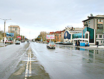
Pavlodar streets
Pavlodar history
Pavlodar started its history in 1720, when an advanced post Koryakovsky was founded among other Russian fortresses and advanced posts on Irtysh River. It was called Koryakovsky due to nearness of storehouses with salt extracted at Koryakovsky Lake. In the second half of 18th century Irtysh fortification lost its military importance. Fortresses and advanced posts turned into common settlements and stanitsas (large Cossack villages). Koryakovsky advanced post became one of salt-extracting centers in Siberia region. In 1838 it was reformed into stanitsa Koryakovskaya. Advantageous location of the stanitsa: on the bank of the large navigable river, close to areas where deposits of lead, copper and silver were worked, crossroads of trade ways with nomad steppes - all these facts were very advantageous for economic development of the settlement. In 1861 Koryakov received the status of the town with the name Pavlodar, in honor of newborn Great Prince Pavel Alexandrovich. A little later the town became the district center in Semipalatinskaya oblast. General plan of the town building was adopted - there is its copy in the museum of the city. In the 30s of 20 century all the churches in Pavlodar and minaret on the mosque were destroyed. The decision to construct a grain harvester combine plant and an aluminum plant was a start for new powerful construction in Pavlodar city. In early January 1955 first builders began arriving to Pavlodar. At the same time houses for future workers of plants were constructed. Since 1956 the population of Pavlodar began to grow intensely.
Pavlodar city scenery
Pavlodar city, Kazakhstan scenery
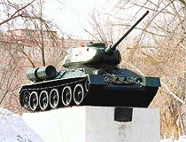
Pavlodar city T-34 tank monument
Ekibastuz city
Ekibastuz (also spelled Ekibastus) is a city located in Pavlodar oblast (region) of Kazakhstan, north-west of Pavlodar city. There is an airport in Ekibastuz city.
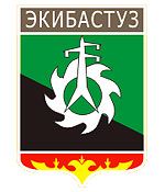
Ekibastuz city coat of arms
Ekibastuz history
Ekibastuz history began in the 19th century. Kosim Pshembaev - a native Kazakh commissioned by Russians to look for minerals in Pavlodar region - found a coal field north-west of Pavlodar city. To mark the place he placed two big lumps of salt. And it gave the place its current name because "Ekibastuz" means "two lumps of salt" in Kazakh language. Soon the railroad was constructed and Ekibastuz settlement was founded in 1899.
The revolutions of 1917 in Russia and two World Wars distracted the attention from the exploitation of Ekibastuz coal field. Ekibastuz village was almost deserted. But in 1948 the first team of about 50 people started construction of the future Ekibastuz town.
December 1954 is an important date of Ekibastuz history. It was the date when the first train loads of coal were loaded. It was the beginning of Ekibastuz industrial development. In 1955 the millionth ton of the coal was produced here. The city status was given to Ekibastuz on 12 July 1957.
Ekibastuz streets

Ekibastuz city street
 Ekibastus city street
Ekibastuz features
Ekibastuz area is one of the biggest open-cast coal field in the world and one of the most perspective. Ekibastuz coal field contains more than 13 billion tons of coal in the area of 62 square kilometers (about 200 million tons of coal per sq. km.).
The climate is of sharp continental type. The territory of Ekibastuz is located very far from the ocean and is open for winds from west and north, this fact lets various air masses reach the area and thus the weather is considerably contrasting. Frosty, moderately severe winters and warm summers are typical for the region.
Ekibastuz attractions
Among the main places of interest of Ekibastuz are:
Open-cast coal mine "Bogatyr". A mine of such a capacity was constructed for the first time in the world. Due to this fact "Bogatyr" was included into the Guinness Book of Records in 1980 (over 1 billion tons of coal was mined within the whole period of exploitation). 50 million tons is mined a year. The miners of this open-cast had the honored right to dispatch the billionth ton of coal mined at Ekibastuz deposit in 2000.
Power station 2. The unique pipe of the station, 420 m high, was included into the Guinness Book of Records. The station produces electric power out of Ekibastuz coal with 2 energy blocks 500 Mwtt each, it possesses the set up capacity 1000 Mwtt. The energy produced by the station is aimed at providing the north of Kazakhstan and it covers 15% of energy consumed by the republic.
Dozens plants in Kazakhstan as well as Russia are users of this energy. Among them are space port Baikonur, canal Irtysh-Karaganda.
Super powerful electricity transmission line with the voltage of 1,500 kv Ekibastuz-Center 2,414 km long is the longest electricity transmission line in the world. Its first pylon was erected in December 1980. Since that time 4,000 pylons (41 m high) stretched westwards across the rivers Irtysh, Ishim, Tobol, Ural and Volga till Tambov, thus connecting Kazakhstana and Russia.
Ekibastuz mosque. It was opened in September 1998. It became a decoration of the city and was admitted one of the most beautiful mosques in Kazakhstan.
Ekibastuz cathedral. The construction of Seraphim-Iversky cathedral was started in 1992, on September 21st, 2000, it was finished.
United States of America
The United States of America is the fourth largest country in the world, after Russia, Canada and China. It occupies the southern part of North America, and includes Alaska.
The USA is made up of 50 states, and the District of Columbia, a special federal area where the capitol of the country is situated.
If we look at the map of the USA, we can see lowlands and mountains. The highest mountains are the Rocky Mountains and the Sierra Nevada. The highest peak is Mount McKinley which is located in Alaska. The United States is a land of rivers and lakes. The largest and deepest lakes in the USA are the fiveGreat Lakes on the border with Canada. America's largest rivers are the Mississippi, the Missouri, the Rio Grande and the Columbia. The Mississippi is the word's third longest river after the Nile and the Amazon. The climate of the country varies greatly. The climate of Alaska is arctic. The climate of the central part is continental. The south has subtropical climate.
The history of the country is rather long. Christopher Columbus sailed from Spain across the Atlantic Ocean. Instead of reaching India as he had expected he landed on an island off a continent unknown to Europeans, but he thought that he was in India.
In the southern states white farmers used black slaves to work on their huge plantations. When slavery was stopped in the North the southern states left theUnion and formed the Confederacy. Civil war between the North and the South started. The Union won and the slavery was abolished all over the USA. Nowadays, the USA is highly developed industrial country.
There are many important cities in the USA, for example New York, one of the largest cities in the world, a great seaport and financial center, Chicago near the Great Lakes, one of the biggest industrial cities in the USA, and the second largest after New York. Boston is one of the first cities which were built on the Atlantic coast of America. Now it is a big cultural centre with three universities. Los Angeles is a centre of modern industries and show business. Other big and important cities of the USA are Philadelphia, Dallas, San Francisco, Detroit, Washington and so on.
Washington D.C. is the capitol of US. It is situated in the District of Columbia and is like no other city in America. it's the world's largest one-industry city. And that industry is government. The White House, where the US president lives and works, the Capitol, the home of the US congress, and the Supreme Court, are all in Washington. The city was so named in memory of George Washington, the first president of the USA, known for the active participation in the war with Britain. A special district was created for the city - the District of Columbia. The city was laid out according to be a capitol. Washington is one of the most magnificent and unusual cities in the USA. In the centre of it rises the huge dome of the Capitol - a big white dome standing in a circle of pillars. It's rather easy to get lost in this huge building, full of paintings and statues.
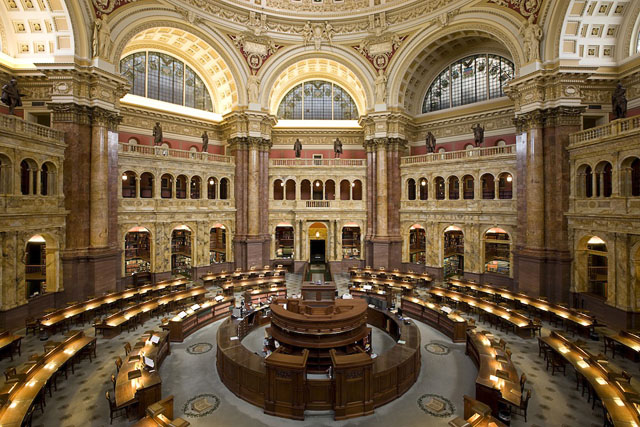
Not far from the Capitol is the library of Congress, the largest in US. It contains more than 13 million books, more than 19 million manuscripts, including the personal papers of the American presidents.
The official residence of the USA president is White House. It has 132 rooms, among them the Oval Office where the president works. The White House used to be a president residence since it first occupied by President John Adams in 1800.
One can hardly find a park, a square or an open area in Washington without a monument or a memorial, the Jefferson Memorial was built in honor of Thomas Jefferson, the author of the Declaration of Independence and the third president of the USA. Inside his statue, and his writings are inscribed on the walls. The Lincoln Memorial reminds everybody of Abraham Lincoln, the sixteenth American president who's noted for the slavery destruction. There's a statue of Abraham Lincoln inside the memorial. At the National Air and Space Museum visitors can see the history of flight from the first airplane to the Apollo spaceship. The National Gallery of Art, a large museum of painting, sculpture and other arts is also situated in the capitol.
From the beginning of the twentieth century the USA became the world's leading country. Thousands of tourists visit Washington every day. People from all parts of the US come to see their capitol, and also people all over the world. Washington greets tourists with the Cherry Blossom festival every spring. The pink and white blossoms of the Japanese cherry these near the Washington Monument create a magnificent delicate picture, and you are to visit Washingtonjust to see it, and then all beauties of other cities will seem to you gloomy.

Florida
Florida is one of the USA states. It is located in the south-eastern part of the USA. It is a peninsula territory. The capital of the state is Tallahassee. The total population of Florida is about 16,000,000. It occupies the 4th place in the USA according to the number of citizens. The total area of the state is about 58,500 square miles. The great deal of territory is covered by marshes.
It stretches from north to south on 447 miles and from east to west on 361 miles. The total length of the beaches is 663 miles.
The biggest city is Miami.
Written records about Florida date back to the arrival of the Spanish explorer and adventurer Juan Ponce de Leon in 1513. He called the area la Florida, in honour of Pascua florida («feast of the flowers»), Spain's Easter time celebration. Other Europeans may have reached Florida earlier, but no firm evidence of such achievement has been found.
Spain was not the only European nation that found Florida attractive. In 1562 the French explored the area. These French adventurers prompted Spain to accelerate her plans for colonization. In fact, in the beginning of the 17th century Spain's power over what is now the south-eastern United States was unquestioned.
Britain gained control of Florida in 1763 in exchange for Havana, Cuba, which the British had captured from Spain during the Seven Years' War (1756-63). Spain evacuated Florida after the exchange, leaving the province virtually empty. The British had ambitious plans for Florida.
It was split into two parts: East Florida and West Florida. The two Floridas remained loyal to Great Britain throughout the War for American Independence (1776-83); However, Spain, participating indirectly in the war, captured West Florida from the British in 1781. In 1784 it regained control of the rest of Florida as part of the peace treaty that ended the American Revolution.
When the British evacuated Florida, Spanish colonists as well as settlers from the newly formed United States came pouring in. Finally, after several official and unofficial U.S. military expeditions into the territory, Spain formally ceded Florida to the United States in 1821. Territorial Period began and on March 3, 1845 Florida became the twenty-seventh state of the United States.
Questions:
1. Where is Florida located?
2. What is the capital of the state?
3. What place does Florida occupy according to the number of citizens?
4. Are there beaches in Florida?
5. What is the biggest city of the state?
6. Who called the area la Florida?
7. Was Spain the only European nation that found Florida attractive?
8. When did Britain gain control of Florida?
9. When did Spain formally cede Florida to the United States?
10. When did Florida become a state of the USA?
Texas
Texas is the 28th American state, which is situated in the south of the country and could be denoted as the southeast continental part of the USA. Texas has border with other USA states: Arkansas, Oklahoma, New Mexico and Louisiana. The State is washed by the Gulf of Mexico.
Certainly, this state has its nickname: Lone Star State.
The origin of state's name comes from a word used by Cad-do Indians meaning «friends».
Texas became an American State on December 28,1845 after the War with Mexicans.
Its agricultural sector produces cotton, dairy products, poultry, corn, and wheat. If we speak about Texas industry, we should mention chemical industry, machinery, electric equipment, mining, extracting of natural gas and petroleum.
Texas geographic centre is McCulloch, 15 miles northeast of Brady. The highest point of Texas is Guadalupe Peak - 8,749 feet. Largest Cities are Houston, Dallas, San Antonio, Austin and El Paso.
The population of Taxes is about 20 852 000 people (2001). Comparing the density of population of all American States Taxes occupies the second place.
It is the motherland for the following presidents:
Dwight David Eisenhower 1953-1961 (the 34th President of the USA), who was born in 1890, in Denison, Texas;
Lyndon Baines Johnson, 1963-1969 (the 36th President of the USA), who was born in 1908, near Johnson City, Texas
Present Governor of Texas is Rick Perry (2003).
Questions:
1. Is Texas an American state?
2. When did Texas become the state of the USA?
3. What is the origin.of the word Texas?
4. How many presidents of the USA were born in Texas?
5. What is the nickname for Texas?
6. Where is Texas situated?
7. What part of the country does Texas occupy?
8. What are the biggest Texas cities?
USA Holidays
Holiday is a day set apart for religious observance or for the commemoration of some extraordinary event or distinguished person, or for some other public occasion.
National holidays are days set aside by official government proclamation to celebrate different occasions.
The U.S. has no national holidays. Legal holidays - days on which banks, schools, or other public institutions and most places of business are closed.
Memorial Day is a legal holiday, observed annually on the last Monday in May in most of the United States, It honours the nation's armed services killed in wartime. The holiday, originally called Decoration Day, is traditionally marked by parades, memorial speeches and ceremonies, and the decoration of graves with flowers and flags. Memorial Day was first observed on May 30, 1868, on the order of General John Alexander Logan for the purpose of decorating the graves of the American Civil War dead. It was observed on May 30 until 1971, when most states changed to a newly established federal schedule of holiday observance.
Independence Day is an annual holiday commemorating the formal adoption by the Continental Congress of the Declaration of Independence on July 4, 1776, in Philadelphia. Although the signing of the Declaration was not completed until August, the Fourth of July holiday has been accepted as the official anniversary of United States independence and is celebrated in all states and territories of the U.S.
The Fourth of July is traditionally celebrated publicly with parades and pageants, patriotic speeches, and organised firing of guns and cannons and displays of fireworks. Family picnics and outings are a feature of private Fourth of July celebrations.
Thanksgiving Day, a legal holiday in the U.S., was first celebrated in early colonial times in New England. The actual origin is probably the harvest festivals that are traditional in many parts of the world. After the first harvest was completed by the Plymouth colonists in 1621, Governor William Bradford proclaimed a day of thanksgiving.
In 1863 President Abraham Lincoln appointed a day of thanksgiving, and since then each president has issued a Thanksgiving Day proclamation, generally designating the fourth Thursday of November as a holiday.
New Year's Day is the first day of the year, January 1 in the Gregorian calendar. In the Middle Ages most European countries used the Julian calendar and observed New Year's Day on March 25, called Annunciation Day and celebrated as the birth to the Son of God. With the introduction of the Gregorian calendar in 1582, Roman Catholic countries began to celebrate New Year's Day on January 1.
The custom of visiting friends, relatives and neighbours on New Year's Day is one of the Old World traditions that has taken on a new form in the United States. A favourite place to see the old year out is New York City's Time Square.
Christmas is an annual festival, held on December 25, to celebrate the Nativity, or birth of Christ. The Christmas tree, an evergreen trimmed with lights and other decorations, is derived from the so-called paradise tree, symbolising Eden.
Saint Valentine's Day, a holiday honouring lovers, is celebrated on February 14. There is a custom of sending greeting cards or gifts to express affection. The cards, known as valentines, are often designed with hearts to symbolise love. The holiday probably derives from the ancient Roman feast of Lupercalis (February 15). The festival gradually became associated with the feast day (February 14) of two Roman martyrs, both named St. Valentine, who lived in the 3rd century. St. Valentine has traditionally been regarded as the patron saint of lovers.
Native Plants and Animals
Native Plants
With extremes of climate ranging from arctic to tropical, and with landforms that include mountains, plains, deserts, and swamps, the United States has a rich variety of plant life.
Forests. When Europeans first came to North America, forest covered almost all the area now included in the United States east of the Mississippi River. Prairies and other grasslands extended westward from the Mississippi to the Rockies, where forests began again. The clearing of land for farming and unrestricted lumbering destroyed many of the forests, especially in the Midwest and East.
Today, Alaska has the greatest forested area in the United States, followed by California and Oregon. Extensive forests are also found in the South and in the Northeast and in the Great Lakes states.
Coniferous, or cone-bearing, trees grow mainly in the Northeast, in the Rocky Mountain region, on the Pacific Coast, in Alaska, and in the South. Fir, spruce, and red and white pines are among the most common trees in the Northeast. Engelmann spruce, ponderosa pine, western white pine, lodgepole pine, and Douglas fir are among the chief trees in the Rockies. On the Pacific Coast are Douglas fir, ponderosa pine, sugar pine, red cedar, and Sitka spruce. The giant redwoods grow in California.
Hemlock and Sitka spruce form dense forests on the southeast coast of Alaska. There are forests of white spruce mixed with broadleaf trees such as white birch and aspen in the interior of Alaska. A region of mostly coniferous trees, including longleaf. shortleaf, and loblolly pines, extends from North Carolina to Texas. Bald cypress grows in swamps in the South.
Broadleaf trees are most abundant in the Midwest. These broadleaf trees include oak, elm, maple, beech, hickory, walnut, ash, and birch. Tupelo, red gum, and magnolia are broadleaf trees common in the South. Certain types of palms and other tropical trees grow in the Everglades and in Hawaii.
Grasses
Grasslands occupy the area between the eastern forests and the Rocky Mountains. In the eastern part of this grassland area is the tall-grass prairie, which contains such grasses as big bluestem, Indian grass, and prairie cordgrass. Cities and farms now occupy most of the region.
West of the prairie, roughly west of the 100th meridian, lies the short-grass country of the Great Plains. Here grow buffalo grass, side oats grama, western wheatgrass, and other short and medium grasses.
Flowers
More than 20,000 species of flowering plants are native to the United States, and numerous species introduced from Europe and Asia are now as much a part of the American scene as the native plants. The goldenrod is perhaps the most widespread flower in the United States; it grows in all states except Hawaii.
In the East, the earliest wildflowers to bloom in the spring are woodland plants such as hepaticas, trilliums, bloodroot, and spring beauty. Typical of the Great Plains are sunflowers, blazing stars, pasqueflowers, and lupines. Texas is noted for the bluebonnet and Indian paintbrush.
Bitterroot, harebells, Rocky Mountain columbine, and other hardy plants grow in the Rockies. The numerous desert wildflowers include cacti, yuccas, mariposa lilies, and the desert star. Along the Pacific Coast grow such colorful flowers as poppies and godetias.
Alaska has a rich variety of wildflowers, including harebells, lupines, violets, and hyacinths. Tropical flowers such as hibiscuses, orchids, and the maile, prized for making leis, grow in Hawaii.
Among the common plants introduced from Europe are the dandelions, bouncing bet, yellow iris, and Queen Anne's lace. The tiger lily came from Asia, and the daylilies come from Eurasia.
For various state flowers, see articles on the states.
Desert Plants
Desert areas exist chiefly in Arizona, California, Nevada, and Utah. Sagebrush, greasewood, creosote bush, agaves, yuccas, and cacti are typical plants of the deserts. The giant saguaro cactus and the Joshua tree, a yucca, are the largest desert plants.
Other Plants
Such evergreen shrubs as scrub oak, chamise, and manzanita grow in the chaparral of southern California where there is a Mediterranean-type climate. Mesquite is a thorny shrub or small tree that grows in thorn scrub, semiarid areas in the southwest. Mosses, lichens, and short grasses are characteristic of the arctic tundra, in Alaska, and the alpine tundra, in the Rockies.
Native Animals
The United States has a great variety of animal life, although some once-common animals are extinct and others survive only under government protection. A few wild animals, such as the white-tailed deer, are more abundant than they were in colonial times.
Mammals
Free-ranging bison exist only in preserves, and the musk ox is found in Alaska only because it was reintroduced after it had been exterminated there. Black bears, brown bears (including grizzly bears), and polar bears are the largest carnivores (meateating animals) of the United States. Members of the deer family native to the United States are the white-tailed deer, mule deer, moose, caribou, and American elk.
Members of the dog family include gray and red wolves; red, gray, and arctic foxes; and the coyote. Cat-family members include the mountain lion, bobcat, and lynx. Jaguars and ocelots are sometimes found in the Southwest. Jackrabbits, cottontail rabbits, and snowshoe rabbits are numerous. Among native rodents are beavers, muskrats, porcupines, squirrels, ground squirrels, marmots, and prairie dogs.
There are several native species of weasels and other members of the weasel family, including the marten, fisher, mink, skunk, badger, and wolverine. The raccoon is widely distributed. The opossum is the only marsupial (pouched mammal) found in the United States.
Birds
Many kinds of ducks, geese, and other waterfowl are found in the United States. Shorebirds such as plovers, sanderlings, and sandpipers also are numerous. Among native ground birds are the turkey, quail, prairie chicken, and grouse.
Native wading birds include herons, ibises, and egrets. Among birds of prey are numerous species of hawks and owls and the golden and bald eagles. The buzzard and the California condor are native carrion-feeding birds. Among the hundreds of kinds of songbirds are thrushes (including robins), warblers, cardinals, tanagers, sparrows, and bobolinks.
Reptiles
Alligators and crocodiles are found in Florida. Among the many kinds of turtles are the snapping turtles, the alligator snappers, box turtles, and desert tortoises. Rattlesnakes are found in almost all of the states, but chiefly in the Southwest. Other poisonous snakes include the water moccain in, found in the Southeast and coral snakes, found in the Gulf Coast states and in the Southwest. The many kinds of nonpoisonous snakes include bull snakes, hognose snakes, king snakes, and garter snakes. Lizards are most numerous in the Southwest. The Gila monster, a venomous lizard, lives chiefly in deserts of the Southwest.

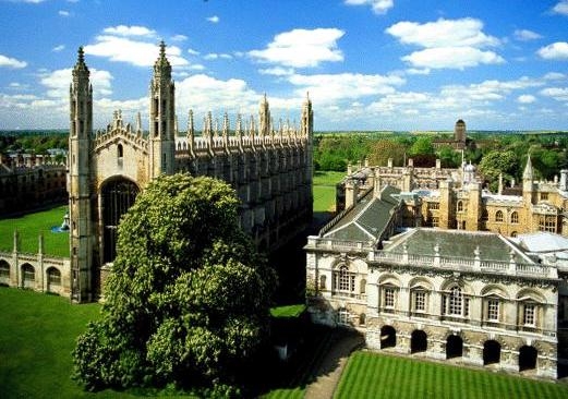
University of Oxford
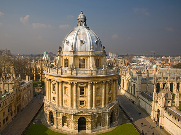
The University of Oxford (informally Oxford University or simply Oxford) is a collegiate research university located in Oxford, England. While having no known date of foundation, there is evidence of teaching as far back as 1096, making it the oldest university in the English-speaking world, and the world's second-oldest surviving university.It grew rapidly from 1167 when Henry II banned English students from attending the University of Paris After disputes between students and Oxford townsfolk in 1209, some academics fled northeast to Cambridge, where they established what became the University of Cambridge. The two "ancient universities" are frequently jointly referred to as "Oxbridge". The University is made up from a variety of institutions, including 38 constituent colleges and a full range of academic departments which are organised into four Divisions All the colleges are self-governing institutions as part of the University, each controlling its own membership and with its own internal structure and activities. Being a city university, it does not have a main campus; instead, all the buildings and facilities are scattered throughout the metropolitan centre. Most undergraduate teaching at Oxford is organised around weekly tutorials at the self-governing colleges and halls, supported by classes, lectures and laboratory work provided by university faculties and departments. Oxford is also the home of several notable scholarships, including the Clarendon Scholarship which was launched in 2001 and the Rhodes Scholarship which has brought graduate students to read at the university for more than a century Oxford holds the largest university press in the world and the largest academic library system in the United Kingdom.
Oxford has educated many notable alumni, including 27 Nobel laureates (58 total affiliations), 26 British Prime Ministers (most recently David Cameron) and many foreign heads of state.

The University of Cambridge (informally known as "Cambridge University" or simply "Cambridge"; abbreviated as "Cantab" in post-nominals is a collegiate public research university in Cambridge, England. Founded in 1209, Cambridge is the second-oldest university in the English-speaking world and the world's third-oldest surviving university. It grew out of an association formed by scholars leaving the University of Oxford after a dispute with townsfolk; the two "ancient universities" have many common features and are often jointly referred to as "Oxbridge". Cambridge is formed from a variety of institutions which include 31 constituent colleges and over 100 academic departments organised into six Schools. The university occupies buildings throughout the town, many of which are of historical importance. The colleges are self-governing institutions founded as integral parts of the university. In the year ended 31 July 2013, the university had a total income of £1.44 billion, of which £332 million was from research grants and contracts. The central university and colleges have a combined endowment of around £4.9 billion, the largest of any university outside the United States. Cambridge is a member of many associations, and forms part of the "golden triangle" of English universities and Cambridge University Health Partners, an academic health science centre. The university is closely linked with the development of the high-tech business cluster known as "Silicon Fen". Students' learning involves lectures and laboratory sessions organised by departments, and supervisions provided by the colleges. The university operates eight arts, cultural, and scientific museums, including the Fitzwilliam Museum, and a botanic garden. Cambridge's libraries hold a total of around 15 million books, 8 million of which are in Cambridge University Library which is a legal deposit library. Cambridge University Press, a department of the university, is the world's oldest publishing house and the second-largest university press in the world. Cambridge is regularly placed among the world's best universities in different university rankings. Beside academic studies, student life is centred around the colleges and numerous pan-university artistic activities, sports clubs and societies.
Cambridge has many notable alumni, including several eminent mathematicians, scientists, politicians, and 90 Nobel laureates have been affiliated with it. Throughout its history the university has featured heavily in literature and artistic works by various authors.
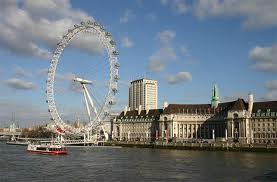
London
London is the capital of Great Britain, its political, economic, and commercial centre. It is one of the largest cities in the world and the largest city in Europe. Its population is about 8 million.
London is divided into several parts: the City, Westminster, the West End, and the East End.
The heart of London is the City, its financial and business centre. Numerous banks, offices, and firms are situated there, including the Bank of England, the Stock Exchange, and the Old Bailey. Few people live here, but over a million people come to the City to work. There are some famous ancient buildings within the City. Perhaps the most striking of them is the St. Paul's Cathedral, the greatest of English churches. It was built in the 17th century by Sir Christopher Wren. The Tower of London was founded by Julius Caesar and in 1066 rebuilt by William the Conqueror. It was used as a fortress, a royal palace, and a prison. Now it is a museum.
Westminster is the governmental part of London.
Nearly all English kings and queens have been crowned in Westminster Abbey. Many outstanding statesmen, scientists, writers, poets, and painters are buried here: Newton, Darwin, Chaucer, Dickens, Tennyson, Kipling, etc.
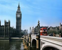
Across the road from Westminster Abbey is Westminster Palace, the seat of the British Parliament. The Clock Tower of the Houses of Parliament is famous for its big bell, known as "Big Ben". Buckingham Palace is the official residence of the Queen.
The West End is the richest and most beautiful part of London. It is the symbol of wealth and luxury. The best hotels, shops, restaurants, clubs, and theatres are situated there.
The Trafalgar Square is the geographical centre of London. It was named in memory of Admiral Nelson's victory in the battle of Trafalgar in 1805. The tall Nelson's Column stands in the middle of the square.
On the north side of the Trafalgar Square is the National Portrait Gallery. Not far away is the British Museum - the biggest museum in London. It contains a priceless collection of ancient manuscripts, coins, sculptures, etc, and is also famous for its library.
There are a lot of factories, workshops, and docks in the East End.
Questions:
1. Is London the largest city in the world?
2. What's the population of London?
3. Traditionally London is divided into four parts. Can you name them?
4. What do you know about the City?
5. Who was the St. Paul's Cathedral built by?
6. Who founded the Tower of London? When was it rebuilt?
7. What is the governmental part of London?
8. What building has more historic associations than any other building in London?
9. What is Big Ben?
10. Can you describe the Trafalgar Square?
11. Where do the working people of London live?
12. What are the most famous London museums and art galleries?
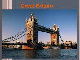
Great Britain
The full name of the country the United Kingdom of Great Britain and Northern Ireland. The United Kingdom is situated on the British Isles. The British Isles consist of two large islands, Great Britain and Ireland, and a great number of small islands. Their total area is over 314 000 sq. km. The British Isles are separated from the European continent by the North Sea and the English Channel. The western coast of Great Britain is washed by the Atlantic Ocean and the Irish Sea. Northern Ireland occupies one third of the island of Ireland. It borders on the Irish Republic in the south. The island of Great Britain consists of three main parts: England (the southern and middle part of the island), Wales (a mountainous peninsula in the West) and Scotland (the northern part of the island).
There are no high mountains in Great Britain. In the north the Cheviots separate England from Scotland, the Pennines stretch down North England along its middle, the Cambrian mountains occupy the greater part of Wales and the Highlands of Scotland are the tallest of the British mountains. There is very little flat country except in the region known as East Anglia. Most of the rivers flow into the North Sea. The Thames is. the deepest and the longest of the British rivers. Some of the British greatest ports are situated in the estuaries of the Thames, Mersey, Trent, T Clyde and Bristol Avon. Great Britain is not very rich in mineral resources, it has some deposits of coal and iron ore and vast deposits of oil and gas that were discovered in the North Sea.
The warm currents of the Atlantic Ocean influence the climate of Great Britain. Winters are not severely cold and. summers are rarely hot. The population of the United Kingdom is over 58 million people. The main nationalities are: English, Welsh, Scottish and Irish. In Great Britain there are a lot of immigrants from former British Asian and African colonies. Great Britain is a highly industrialized country. New industries have been developed in the last three decades. The main industrial centres are London, Birmingham, Manchester, Leeds, Liverpool, Glasgow and Bristol. The capital of the country is London. The United Kingdom is a parliamentary monarchy.
Questions:
1. Where is the United Kingdom situated
2. What islands do the British Isles consist of?
3. What ocean and seas are the British Isles washed by?
4. How many parts does the Island of Great Britain consist of and what are they called?
5. What country does Northern Ireland border on?
6. Are there any high mountains in Great Britain?
7. What sea do most of the rivers flow into?
8. What mineral resources is Great Britain rich in?
9. What is the climate like in Great Britain?
10.What is the population of Great Britain?
11.What city is the capital of the U. K.?
12. What kind of state is Great Britain?
London
London is the capital of the United Kingdom of Great Britain and Northern Ireland, situated on both sides of the Thames River; it's the political, financial, commercial, industrial, and cultural centre of Great Britain. It is the largest city in Europe with the total population of about 8 million people (over 12 million with the suburbs). About one fifth of the total population of the UK lives in Greater London, that is in London with its suburbs.
London is home for the headquarters of all government departments, Parliament, the monarch and all the major legal institutions. It's the country's business and banking centre and the centre of its transport network. It contains the headquarters of National television networks and of all the national newspapers. The financial services sector is a major source of overall employment in London.
Consumer goods, clothing, precision instruments, jewelry, and stationery are produced in London, but manufacturing has lost a number of jobs in the once-dominant textile, furniture, printing, and chemical-processing industries as firms have moved outside the area. Engineering and scientific research are also important to the economy, as is tourism. The city is a centre for road, rail, and air (its airports include Heathrow and Gatwick), and it is now linked to the Continent by a high-speed rail line under the English Channel. London still remains one of the world's greatest ports. It exports manufactured goods and imports petroleum, tea, wool, raw sugar, timber, butter, metals, and meat.
The original walled city of London (then Londinium) founded by Romans was quite small. In the Middle Ages it did not contain the Parliament or the royal Court, because it would have interfered with the interests of the merchants and traders living there. It was in Westminster, another city outside London's walls, that these national institutions met. Today, both 'cities' are just two areas in Central London. The City is London's commercial centre; it is also referred to as the "Square Mile of Money' because of its area. The Bank of England, Lloyd's, the stock exchange, the Royal Exchange and numerous other banks and investment companies have their headquarters there. The City of Westminster contains London's most famous tourist attractions: Westminster Abbey, the Houses of Parliament and so on.
London is a cosmopolitan city. People of several races and many nationalities live there. A survey carried out in the 90s found that 137 different languages were spoken in the homes of just one district of London.
Manchester
Manchester is one of the English most important cities. It is located in the northern part of England, not far from Liverpool. Today the population of Manchester is 438,000.Manchester began, when a wooden fort was built by the Roman army on a plateau about 80 AD. The fort was rebuilt in stone about 200 AD. Soon a civilian settlement grew up around the fort.
However in 407 the Roman army left Britain and the civilian settlement disappeared. The stone fort fell into ruin.
In 7th century the Saxons created a new village, but it was tiny. The surrounding area was thinly populated and was mostly forest. The Saxons called any Roman town or fort a caester. They called the old fort at Manchester Mamm caester. The village nearby took its name from the fort. By 1086 the settlement was called Mamecester. In time the name changed to Manchester. In 919 the king repaired the old Roman fort as a defence against the Danes.
At the time of the Normans in the 11th century Manchester was a small village, but things changed in the 12th century. The population of the country grew and trade and commerce developed rapidly. Many new towns were founded. The village of Manchester was made into a town in the early 13th century. In the year 1222 Manchester was granted the right to hold an annual fair. In the Middle. The town continued to be famous for manufacturing wool, cotton, linen and silk. The first theatre in Manchester opened in 1753. In the early 19th century Manchester became world famous as a manufacturing centre. Wool, silk and cotton were manufactured and vast numbers of working people worked 12 hour days in the mills. There was also a paper making industry and iron foundries. Manchester University was founded in 1903. The central library was built in 1934.
Questions:
1. Where is Manchester located?
2. What population has Manchester today?
3. When was Manchester founded?
4. When was the fort rebuilt in stone?
5. How did the Saxons call any Roman town or fort?
6. When was the village of Manchester made into a town?
7. When was Manchester granted the right to hold an annual fair?
Liverpool
Liverpool, as the maritime capital of Britain, has a reputation as an unglamorous working-class town, and it is tragedy deserted dockside area reflects the hardships wrought by the economic change of the 1980s. Yet mo Liverpool can boast of world-class theatres, a symphony orchestra, a variety of restaurants and thriving nightly. Liverpool is a world city of international renown, with its instantly recognizable waterfront, unique accent and famous sons and daughters. Based in the heart of Northwest England, Liverpool is also Britain"s favourite day trip destination according to the national tourist board.
Liverpool, with its famous waterfront on the River Mersey, is a great shipping port and industrial center. King John launched it on its road to glory when he granted it a charter in 1207. Before that, it had been a tiny 12th-century fishing village, but it quickly became a port for shipping men and materials to Ireland. In the 18th century, it grew to prominence because of the sugar, spice, and tobacco trade with the Americans. By the time Victoria came to the throne, Liverpool had become Britain's biggest commercial seaport.
As the birthplace of the Beatles, Liverpool has long been a popular tourist attraction. But the Beatle heritage is the character of the «Scouse» people than in such workaday landmarks as Strawberry Fields and the «Eleanor Indeed», the fabled Cavern Club, where the Beatles honed their craft, has been razed. The real secret of the Beatles dockside melting pot ensured a continual influx of less-than-proper music and attitudes from overseas. Visitors who simply must get the official version of events are directed to the city-sponsored Beatle exhibit and Dock. The Albert Dock itself is widely considered Britain's most successful large-scale tourist renovation.
Recent refurbishing of the Albert Dock, the establishment of a Maritime Museum, and the conversion of warehouses into little stores similar to those in Ghirardelli Square in San Francisco have made this an up-and-coming area once again, with many attractions for visitors. Liverpudlians are proud of their city, with its new hotels, two cathedrals, shopping and entertainment complexes, and parks. And of course, whether they are fans of the Fab Four or not, most visitors to Liverpool want to see where Beatlemania began.
Animals and plants of Great Britain
In most of Great Britain there is a temperate climate which receives high levels of precipitation and medium levels of sunlight. Further northwards, the climate becomes colder and coniferous forests appear replacing the largely deciduous forests of the south. There are a few variations in the generally temperate British climate, with some areas of subarctic conditions in areas such as the Scottish Highlands and Teesdale, and even sub-tropical in the Isles of Scilly. The seasonal changes that occur across the archipelago mean that plants have to cope with many changes linked to levels of sunlight, rainfall and temperature, as well as the risk of snow and frost during the winter.
Since the mid eighteenth century, Great Britain has gone through industrialisation and increasing urbanisation. A DEFRA study from 2006 suggested that 100 species have become extinct in the UK during the 20th century, about 100 times the background extinction rate.[3] This has had a major impact on indigenous animal populations. Song birds in particular are becoming scarcer and habitat loss has affected larger mammalian species. Some species have however adapted to the expanding urban environment, particularly the red fox, which is the most successful urban mammal after the brown rat, and other animals such as common wood pigeon.
Traditions and holidays of Great Britain
Traditions and holidays of Great Britain. Every nation and every country has its own traditions and customs. Traditions make a nation special. Some of them are old-fashioned and many people remember them, others are part of people s life. Some British customs and traditions are known all the world. From Scotland to Cornwall, Britain is full of customs and traditions. A lot of them have very long histories. Some are funny and some are strange.
But they are all interesting. There is the long menu of traditional British food. There are many royal occasions. There are songs, saying and superstitions. They are all part of the British way of life. You cannot really imagine Britain without all its traditions, this integral feature of social and private life of the people living on the British Isles that has always been an important part of their life and work.
English traditions can classified into several groups traditions concerning the Englishmen s private life child s birth, wedding, marriage, wedding anniversary which are connected with families incomes state traditions national holidays, religious holidays, public festival, traditional ceremonies. What about royal traditions There are numerous royal traditions in Britain, some are ancient, others are modern. The Queen is the only person in
Britain with two birthdays. Her real birthday is on April 21st, but she has an official birthday, too. That is on the second Saturday in June. And on the Queen s official birthday, there is a traditional ceremony called the Trooping of the Colour. It is a big parade with brass bands and hundreds of soldiers at
Horse Guard s Parade in London. A regiment of the Queen s soldiers, the Guards, march in front of her. At the front of the parade there is the regiment s flag or colour. Thousands of Londoners and visitors watch in Horse Guards Parade. And millions of people at home watch it on television. This custom is not very old, but it is for very old people.

Australia
Australia is the only country in the world that is also a continent. It is the sixth large country and the smallest continent. Australia lies between the South Pacific Ocean and the Indian Ocean. It is situated about 11 000 km southwest of North America and about 8200 km southeast of mainland Asia. The name of the country comes from Latin word «australis» which mean southern. The country's official name is Commonwealth of Australia.
The Commonwealth of Australia is a federation of states. Australia has six states - New South Wales, Queensland, South Australia, Tasmania, Victoria and Western Australia. Each state has its government. Australia has two territories - the Australian Capital Territory and the Northern Territory. The capital of the country is Canberra.
Australia is a constitutional monarchy like Great Britain. The? nation is administered under written constitution. The British monarch, Queen Elizabeth II, is also queen of Australia and country's head of state. But the queen has little power in the Australian government. She serves mainly as a symbol of long historical tie between Great Britain and Australia. Australia is a member of the Commonwealth of Nations which is an association formed by Britain and some of its former colonies.
Australia is one of the world's developed countries. Australia has modern factories, highly productive mines and farms, and busy cities. It is the world's leading producer of wool and bauxite
Canberra
Canberra (/ˈkænb(ə)rə/ or /kænˈbɛrə/)[4] is the capital city of Australia. With a population of 381,488, it is Australia's largest inland city and the eighth-largest city overall. The city is located at the northern end of the Australian Capital Territory (ACT), 280 km (170 mi) south-west of Sydney, and 660 km (410 mi) north-east of Melbourne. A resident of Canberra is known as a "Canberran". The site of Canberra was selected for the location of the nation's capital in 1908 as a compromise between rivals Sydney and Melbourne, Australia's two largest cities. The Griffins' plan featured geometric motifs such as circles, hexagons and triangles, and was centred on axes aligned with significant topographical landmarks in the Australian Capital Territory.
The city's design was influenced by the garden city movement and incorporates significant areas of natural vegetation that have earned Canberra the title of the "bush capital". The growth and development of Canberra were hindered by the World Wars and the Great Depression, which exacerbated a series of planning disputes and the ineffectiveness of a procession of bodies that were created in turn to oversee the development of the city.
The ACT, like Washington, D.C. in the United States, is independent of any state, to prevent any one state from gaining an advantage by hosting the seat of Federal power. Unlike Washington, however, the ACT has voting representation in the Federal Parliament, and has its own independent Legislative Assembly and government, similar to the states.
As the city has a high proportion of public servants, the federal government contributes the largest percentage of Gross State Product and is the largest single employer in Canberra. As the seat of government, the unemployment rate is lower and the average income higher than the national average, while property prices are relatively high, in part due to comparatively restricted development regulations. Tertiary education levels are higher, while the population is younger.

Animals
When the earth was formed there was only one continent . About 200 million years ago Australia was separated from this big continent and animals developed differently from those that live in other places. That is why Australia has animals which you can't find anywhere else.
Australia's most famous animals are marsupials. They are mammals that have their babies in pouches. Kangaroos, koalas or wallabies are the best-known marsupials in Australia. The platypus is a mammal that lays eggs , from which babies hatch.
Australia has about 700 different types of birds. Among the most famous is the kookaburra. Emus are large birds that cannot fly.
There are many species of reptiles and snakes in Australia, some of which are poisonous.
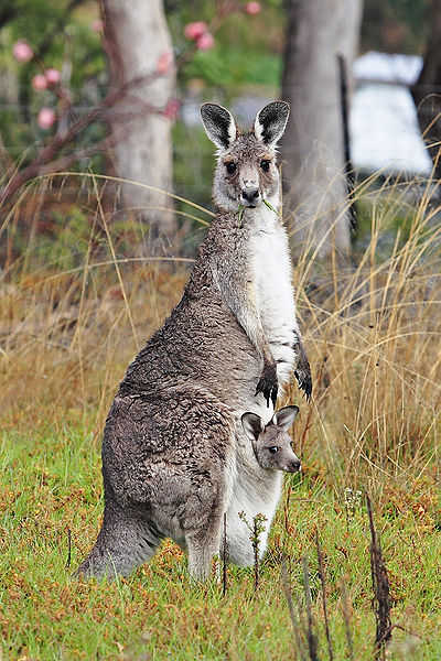
Kangaroo in Eastern Australia
Plants
The eucalyptus or gum tree is a classic Australian tree. It has narrow , oily leaves that look like leather and smell good but also cause the tree to burn easily. It is one of the tallest trees in the world and can grow up to 100 metres.
Tourists who wander around in Australia can find thousands of wildflowers in the country. The seeds lie in the desert during the dry season and when it rains they blossom in all kinds of different colours.
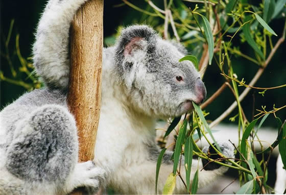
Koala eating eucalyptus leaves
Holidays in Australia
The culture of Australia is rich in both Indigenous and European tradition. Australians love to celebrate their heritage, and most major cities hold unique arts festivals with dance, outdoor music, cinema, food, and wine, at various points throughout the year. Generally, these festivals are completely free of charge, and offer an exciting way to experience the culture of Australia. The country also commemorates a set of national Australian holidays, many with their own celebrations.
National Australian Holidays
One holiday in Australia, observed June 8th to allow a break before winter, is the Queen's Birthday. Generally, schools and government offices will be closed on this day. Another day on which government buildings will likely be closed is January 26, Australia Day. Australia Day commemorates the first British settlement in Australia, in 1788. Today, major cities throughout the country celebrate Australia day with moderate parades, free food, and locally organized events. Sydney hosts a surf board paddle race beneath the Harbor Bridge, in which both amateurs and pros are equally welcome to participate.
One holiday in Australia celebrated both by Australian's, and their New Zealand neighbors alike is ANZAC Day, on April 25. ANZAC Day honors those who have died in wars, and most specifically troops who died fighting during the first World War. ANZAC stands for the Australian and New Zealand Army Corps, and travelers will find parades and ceremonies memorializing the Army Corps in most of Australia's major cities.
Melbourne
Melbourne, city, capital of the state of Victoria, Australia. It is located at the head of Port Phillip Bay, on the southeastern coast. Although the central city is the home of fewer than 100,000 people, it is the core of an extensive metropolitan area-the world's most southerly with a population of more than 1,000,000. In Australia it is second only to Sydney in population, and there is a good-natured rivalry between the two cities, to which geography and history have bequeathed diverse characteristics. Though Melbourne's flat site has led to the regular development of a rectangular pattern of streets, the city has many beautiful parks, and the person with an eye for architectural detail and history can find much that is varied and attractive. Melbourne has a reputation for conservatism and financial soundness-attributes that have contributed to its growth and are revealed by the burgeoning skyline of the central city and the rapidly expanding eastern suburbs. Area City of Melbourne, 14 square miles.
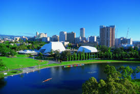
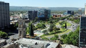
Adelaide
Adelaide, city and capital of the state of South Australia. Situated at the base of the Mount Lofty Ranges, 9 miles (14 km) inland from the centre of the eastern shore of the Gulf St. Vincent, it has a Mediterranean climate with hot summers (February mean temperature 74 °F [23 °C]), mild winters (July mean 54 °F [12 °C]), and an average annual rainfall of 21 inches (530 mm). The site, chosen in 1836 by William Light (the colony's first surveyor general), is on slightly rising ground along the Torrens River, which divides it into a southern business district and a northern residential section. The city is separated from its suburbs by extensive areas of parklands. Named for Queen Adelaide, consort of the British king William IV, it was incorporated as Australia's first municipal government in 1840, but the city council ran into considerable debt and became defunct in 1843. Adelaide was thereafter controlled by the provincial government until 1849, when a city commission was formed.The fertility of the surrounding plains, easy access to the Murray lowlands to the east and southeast, and the presence of mineral deposits in the nearby hills all contributed to the city's growth. As an early agricultural marketing centre, it handled wheat, wool, fruits, and wine.