- Преподавателю
- Иностранные языки
- Разработка урока на тему: Объединенное королевство Великобритании и Северной Ирландии
Разработка урока на тему: Объединенное королевство Великобритании и Северной Ирландии
| Раздел | Иностранные языки |
| Класс | - |
| Тип | Рабочие программы |
| Автор | Актамбердинова Л.М. |
| Дата | 30.11.2014 |
| Формат | doc |
| Изображения | Есть |

"Объединенное королевство Великобритании и Северной Ирландии"
![]()
 Цель урока:
Научить учащихся обобщать и использовать на практике в устной и письменной речи полученную на уроке информацию по теме.
Задачи урока:
-
Научить учащихся монологическим высказываниям, научить рассуждать по заданной теме.
-
Развивать интерес к учебно-познавательной деятельности на ИЯ, развивать умение учебного сотрудничества при выполнении коллективных проектов.
-
Познакомить учащихся с культурой другой страны.
Оборудование:
-
Флаги четырех стран и объединенного королевства.
-
Эмблемы стран королевства.
-
"Слепая карта" Объединенного королевства.
-
Карточки с географическими названиями стран, городов, столиц, рек, озер, гор, морей и т.д.
-
Карточки с индивидуальными заданиями по группам.
-
Карточки с тестами для проверки.
-
Магниты.
ХОД УРОКА
Teacher: A month ago I asked you to work at your project about the United Kingdom of Great Britain and Northern Ireland. Your task was to go to the library or to use Internet to find out some interesting facts about the UK. You were divided into five groups to do this work. I know that you have worked very hard and learnt a lot information about the UK.
But before listening your projects I want you to look at the blackboard to learn some difficult words.
На доске написаны слова, учащиеся читают их вслух за учителем, затем индивидуально.
Stripes [`straips] - полосы,
the patron saint [`peitr n `seint] - святой покровитель,
independent [independent] - независимый,
head of the state [`steit] - глава государства,
to rule [`rul] - править,
conservative [kn`s:vtiv] - консервативный,
the English Chanel [t
 nl] - пролив Ла-Манш,
the strait of Dover [streit v `duv] - Дуврский пролив или пролив Па-де-Кале.
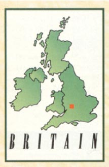
На левой части доски вывешена "слепая карта", изготовленная учащимися. На карте изображено Объединенное королевство, имеющее только границы. Ни одно географическое название не отмечено. На карте лежит иллюстративный материал с названиями городов стран, столиц. Здесь же находятся флаги и эмблемы всех стран в двух видах: стандартном А4 и уменьшенном для нанесения на карту при помощи магнитов.
Teacher: During the pupils` speech I want the other pupils to make the notes about the UK you didn't know before.
Каждая группа учащихся, состоящая из 2 человек, рассказывает о выбранной ими стране, наносит географические названия страны, ее столицы и крупные города, реки, озера, горы, эмблему и флаг на "слепую карту". Здесь же на доску они вывешивают флаг и эмблему страны в стандартном формате на листе.
The first group
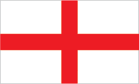
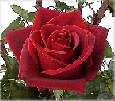
We shall speak about England. It's the largest country in the United Kingdom of Great Britain and Northern Ireland. The capital of England is London. Its land is 130,000 sq. km. The population of England is 48 mln people. The largest cities are Manchester, Liverpool, Birmingham, Nottingham, Sheffield and others. People who live in England are called the English. They speak only English. The famous river Thames is situated in London. The national emblem of England is red rose. The national flag of England represents a red cross on a white field. It's Saint George's Cross of England. England is the heart of Great Britain.
The Second Group
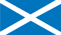
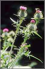
We shall speak about Scotland. It is smaller than England but larger than Wales. The capital of Scotland is Edinburgh. Scotland is the second part of the UK. Its land is 78,000 sq. km. The population of Scotland is 5,3 mln. people. The largest cities are Glasgow, Aberdeen, Dundee. People who live in Scotland are called the Scottish or Scots. They speak Scottish and English. The biggest rivers are Clyde and Spey. There are a lot of beautiful lakes in Scotland. But the most famous of them are Loch Lomond and Loch Ness. The lake "Loch Ness" is famous all over the world because of its monster. The greatest mountains are Ben Nevis and Grampian Hills.
The national emblem of Scotland is a thistle. The national flag is a blue field with white diagonal crossed stripes on it. It's Saint Andrew's Cross.
In the north west Scotland is washed by the Atlantic Ocean, but in the north east it is washed by the North Sea.
The third group
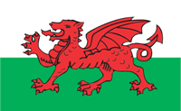
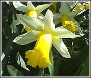
We shall speak about Wales. It's the smallest country in the UK. The capital of Wales is Cardiff. Its land is 20,800 sq. km. Its population is about 2,8 mln people. The largest cities are Swansea, New Port. The biggest river is Usk and the biggest lake is Wirnwel. One of the biggest mountain is Snowdon. The national symbol is a yellow daffodil. The national flag is white and green with a red dragon on it.
The fourth group
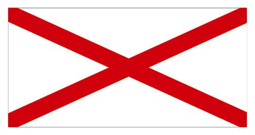
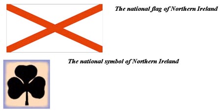
We shall speak about Northern Ireland. It's the fourth country in the UK. Its land is about 14,000 sq. km. The population is about 1,5 mln.people. The capital of the Northern Ireland is Belfast. The largest cities are Ulster and Dublin. The biggest rivers are Shannon, Bun. Northern Ireland is a land of lakes and rivers. The biggest lake is Lock Neagh and Loch Ney. People who live in Ireland are the Irish. They speak Irish and English. The national flag of Ireland represents a diagonal red cross on a white field. It's Saint Patrick's Cross. The national symbol is a green shamrock.
The teacher: During your reports you used such names as "The United Kingdom" or "Great Britain". Are they different or the same? If they are different, tell us about the difference between them.
The fifth group
We shall explain you the difference between these meanings.
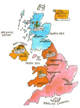
The matter is the United Kingdom of Great Britain and Northern Ireland is the official name of the state which is situated on the British Isles. So Great Britain is often called "Britain" or "the United Kingdom", or "The UK". It consists of four countries which are England, Scotland, Wales and Northern Ireland. Each of them has capital but London is the capital of England, of Great Britain and of the United Kingdom.
It consists of two main islands: Great Britain and Ireland. But only Northern Ireland is the part of the United Kingdom of Great Britain and Northern Ireland.
Ireland is an independent republic. The land of the UK is 244,000 sq. km. The population is about 58 million people. Great Britain consists of three parts. They are: England, Scotland and Wales. The UK is separated from France by the English Channel and Strait of Dover. The UK is also washed by the Atlantic Ocean in the North and the North Sea in the east. Everyone who was born in the UK is the British.
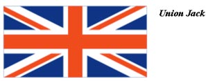
The flag of the UK is known as Union Jack. It is made up of three crosses: the cross of St. George (the patron saint of England), the cross of St. Andrew (the patron saint of Scotland) and the cross of St.Patric (the patron saint of Ireland). The flag was founded in 1801. It symbolizes the union of England, Scotland and Wales. It is called "Jack" because the flag is flown on the jack staff of ships to show their nationality.
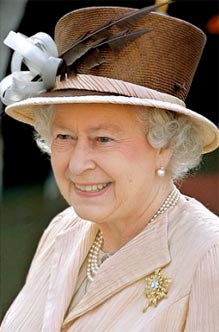
In Britain the Queen is the head of the state, but she doesn't rule the country. The Queen is a symbol of the country history and traditions.
British people are very conservative. They are proud of their traditions and carefully keep them up. But traditions are different in England, Scotland, Wales and Northern Ireland.
Teacher: Let's compare these two maps, your own blind map with the original.
What difference can you name?
We see that they are the same.
"Blind" map made by the pupils
The original map

Teacher: Today at the lesson we have studied a lot of interesting information about the UK. Let's have a test about the UK. You may use your notes. Your task will be to choose and circle the correct answer.
Test
-
The capital of Scotland is:
-
Liverpool
-
Glasgow
-
Cardiff
-
Edinburgh
-
-
The British Isles are separated from the European continent by:
-
The North Sea
-
The English Channel
-
The Atlantic Ocean
-
The Irish Sea
-
-
The national emblem of Wales is:
-
Red rose
-
Daffodil
-
Thistle
-
Shamrock
-
-
People who was born in Great Britain are:
-
The English
-
The Scottish
-
The Welsh
-
The British
-
-
The national flag of Northern Ireland is:
-
A diagonal white cross on a blue field
-
A diagonal red cross on a white field
-
A red dragon on a white and green field
-
A red cross on a white field
-
-
The lake "Loch-Ness" is situated in:
-
England
-
Scotland
-
Wales
-
Northern Ireland
-
-
The head of the UK is:
-
The conservative Party
-
The Labour Party
-
The Parliament
-
The monarch (the queen or the king)
-
-
The most part of population of the UK is concentrated in:
-
England
-
Scotland
-
Wales
-
Northern Ireland
-
-
People who live in Scotland speak:
-
English and Irish
-
English and Scottish
-
English and Welsh
-
Only English
-
Teacher: Your home task will be to sum up the information you've got at our lesson and feel in the factfile in the notes about United Kingdom. You are to do Ex 37 p 101 from your textbooks.
Factfile of the United Kingdom of Great Britain and Northern Ireland
UK
England
Wales
Scotland
Northern Ireland
Land, sq. km
244,000
Population, mln
54
Capital
Largest cities
Rivers
Lakes
Moutains
National Emblems
Flag
Factfile of the United Kingdom of Great Britain and Northern Ireland. (the right filling)
UK
England
Wales
Scotland
Northern Ireland
Land, sq. km
244,000
130,000
21,000
78,000
14,000
Population, mln
54
45
3
5
1
Capital
London
London
Cardiff
Edinburgh
Belfast
Largest cities
Belfast, Cardiff
Liverpool, Oxford
Brecon, Suonsy
Glasgow
Belfast
Rivers
Tay
Thames, Severn
Dee
Spey
Bun
Lakes
Loch-Lomond
District
Woy
Loch-Ness
Loch-Ney
Moutains
Ben Nevis
Pennine Chain
Snowdon
Ben Nevis
Karantuil
National Emblems

Flag