- Преподавателю
- Иностранные языки
- Заповедники Забайкалья методическое пособие
Заповедники Забайкалья методическое пособие
| Раздел | Иностранные языки |
| Класс | 10 класс |
| Тип | Другие методич. материалы |
| Автор | Протасова Ф.Р. |
| Дата | 08.02.2016 |
| Формат | docx |
| Изображения | Есть |

 Ministry of Education of the Russian Federation
Государственное профессиональное образовательное учреждение
Приаргунский сельскохозяйственный техникум
Regional Socio-Cultural Component of Education
Протасова Флюра Рифкатовна
преподаватель английского языка
Priargunsk 2016
RESERVES, NATIONAL PARKS, mountains, rocks AND caves OF the ZABAIKALsky krai
Priargunsk 2016
Пояснительная записка
Учебное пособие составлено в качестве приложения к УМК по английскому языку в виде регионального социокультурного компонента и предназначено для студентов среднего профессионального образования для работы на уроках и во внеурочной деятельности. В брошюре представлено местонахождение и описание заповедников, гор, пещер, скал и национальных природных парков Забайкальского края.
Материал пособия подобран с учетом языкового уровня студентов СПО и позволит расширить рамки учебных занятий по английскому языку. Предлагаемый материал будет иметь познавательный характер и, безусловно, будет интересен студентам.
Материал брошюры можно использовать для изготовления творческих проектов и презентаций.
В концеучебного пособия помещен словарь географических названий.
Nature sights
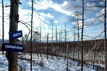
Zabaikalye is a unique region, the land of contrasts. A combination of high mountain glaciers, tundra, hot steppes and deserts cannot but amaze a tourist visiting our land.
Zabaikalsky Krai is unique for its natural attractions: national parks, nature reserves, mountain peaks, lakes, valuable natural communities, as well as historical and architectural sites, among which are the monuments of federal, regional significance and cultural heritage.
This book describes the natural attractions of the Zabaikalsky Krai: reserves, national parks, lakes, cliffs, mountains, caves.
The Southeast of Zabakalie is home to unique objects (monuments, caves, picturesque landscapes, habitats of rare and beautiful plants and animals, etc.) located at specially protected areas of federal significance: in the Alkhanay national park and the buffer zone of Daursky and Sokhondinsky state natural biosphere reserves. This area hosts unique archeological and paleontological monuments: rocks - outliers Adun-Chelona and Haatei Caves, monuments of Buryat national culture Tsugolsky and Aginsky datsans, etc. The territory is also famous for its curative sources (mineral springs, therapeutic muds).

This section describes the unique natural sights of the Zabaikalsky Krai: Daursky reserve, Alkhanay and Chikoy national parks, Ivano-Arakhleisky reserve, Aginskaya Steppe, Mountain steppe, Tsasucheisky Bor reserves and many others.
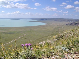
Daursky State Natural Biosphere Reserve (Zapovednik)
Даурский заповедник
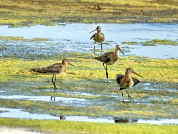
The Daursky State Biosphere Reserve (Zapovednik) is located in the southern part of the Chita Region. The territory of the Reserve consists mainly of steppe landscapes with many typical steppe species of plants and animals, and includes such rare species as the Zeren gazelle, Daurian hedgehog, manul wild cat and the Mongolian marmot (tarbagan). The open spaces of the steppes attract rare birds such as the steppe eagle, golden eagle, falcons, and many species of cranes.
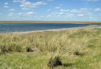
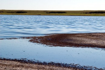
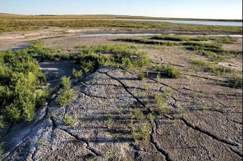
Major highlights of the Reserve are the Torey Lakes (Barun-Torey and Zun-Torey). They are largest lakes of Transbaikalia. A unique feature of these lakes is their periodic filling and drying, occurring on the average once every 30 years. Thus, the lakes were dried up four times in 20th century. The Torey Lakes form separate water basins, receiving water from small steppe rivers. Because of this, the lake waters contain a high concentration of dissolved salts.
The Torey lakes attract many species of birds, which nest on their shorelines. In addition, the lakes are located on the major flyway for migrating species that nest north of the Daursky Reserve. For these reasons the bird fauna in the Reserve is extremely rich (314 species).
The Reserve is also extremely important nesting site for a variety of cranes, one of the largest and most beautiful group of birds in Transbaikalia. Three species of cranes, the Japanese White-naped, the Common and the Demoiselle crane nest in the territory of the Reserve. Two other species of crane, the Great White and the Hooded crane, utilize the Reserve as subadults. In addition, Manchurian cranes were spotted in the Reserve in 2002. Thus, it is possible to observe six species of cranes simultaneously in the Reserve. 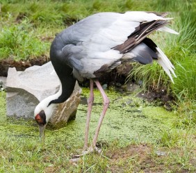
Daursky Reserve in the facts and figures:
Established in 1987.
Surface area: 45, 8 thousand hectares.
Localization: Ononsky and Borzinsky districts of Chita Region.
The largest lakes: Barun-Torey - 550 square km and Zun-Torey - 285 square km.
The Daursky Reserve is part of the Dauria International Protected Territory together with Chinese and Mongolian reserves.
Projected ChikoyNational Park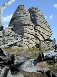
Проектируемый национальный парк "Чикой"
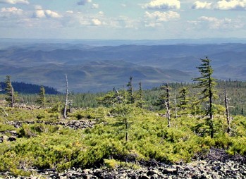
Chikoy National Park is currently in the planning stages. The proposed park has the backing and support of many local citizens and officials and, if established, the park will protect the largest remaining cedar-pine taiga ecosystem in the Chita region. However, progress in the establishment of the park has met resistance from timber companies.
Three Natural Monuments are situated in the area of the proposed park.
1. Lamsky Gorodok (Lama's Town) is an area with picturesque rock outcrops situated in a Pinuspumila forest at an altitude about 1800 м above sea level. (In Transbaikalia this represents a highland.) The boundaries of the park are very close to the Mongolian border. The local inhabitants remember that Buddhist lamas hid here during Stalin's reprisals against religious factions. The lamas retreated from their destroyed datzan (Buddhist temple) near the Semiozer'ye Village. Local legend recounts the fact that the lamas hid a large quantity of gold and the statue of Buddha from the datzan somewhere in, or around, Lamsky Gorodok. There is probably some truth to this legend. Currently, a mining operation is extracting gold nearby in the Chikoy River valley. To appreciate the beauty of this area, one only needs to look at photographs of the river and surrounding forests and mountains. There are very few national parks in the world which can encompass such beauty.
2. Barun-Shabartuy (Bistrinsky Golets) Mountain is the highest summit in Southern Transbaikalia (2519 meters). Glaciers are evident on this mountain.
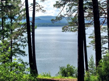
3. Shebetuy Lake is very picturesque taiga lake.
The Chikoy National Park would be ideally suited for adventure travelers since the terrain is difficult and the logistics of getting to this area require long and complicated travel arrangements.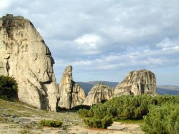
A very important reason for protecting this region is the fact that rivers that originate in this area carry waters to the "well of the Planet" - Baikal Lake. In addition, the WWF considers the Siberian taiga as one of the Global 200 Ecoregions of the World.
Ivano-Arakhleisky State Natural Landscape Reserve (Zakaznik)
Ивано-Арахлейский заказник
Ivano-Arakhleisky Reserve (Zakaznik) is located 70 kms from Chita city. This Zakaznik was created to protect the natural lake ecosystems associated with the most heavily utilized recreation area in the Chita Region. In one year this Natural Landscape Reserve was visited by more than 150 thousand people utilizing numerous camps for rest or a "wild" adventure.
This Zakaznik protects and minimizes human impact on the land and lake waters, with a priority to prevent unauthorized construction and pollution of the lakes' shorelines.
An excellent asphalt road connects Chita city to the Zakaznik crossing the Yablonovy Ridge.
The Ivano-Arakhley lakes have always attracted tourists with their picturesque landscapes, pure water and air, therapeutic mud, fishing, hunting, proximity to Chita (70 km) and transport accessibility. The lakes are accessible by highway, improved earth road and well beaten country roads. In 2003 Ivano-Arakhley natural reserve had 196 cabin resorts and 10 sports and recreation childrens' camps. Each year the lakes are visited by 163,000 people.
Ivano-Arakhleisky Reserve (Zakaznik) in the facts and figures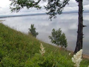
Established in 1993.
Surface area: 210 thousand hectares.
Localization: Chitinsky District of the Chita Region.
Basic natural assets: 6 large lakes, over 20 small lakes, a larch taiga, and birch and aspen forests.
Villages: Beklemishevo, Preobrazhenka, Arakhley, etc.
Land users: one agricultural enterprise and two timber enterprises.
Permissible activities: agriculture, amateur hunting and fishing.
Prohibited activities: industrial logging, trade hunting, accommodation of warehouses, application of pesticides, drainage of polluted water, and illegal dumping.
Special significance: this Zakaznik is part of the basin of Baikal Lake. In fact it is the most remote point of the Baikal basin.
Aginskaya Steppe State Reserve (Zakaznik)
Заказник "Агинскаястепь"
Aginskaya Steppe State Reserve located in Aginskiy District. Surface area: 45,8 thousand hectares. It was established in 2004. The purpose of the reserve is to conserve and restore natural ecosystems.
Mountain Steppe State Reserve (Zakaznik)
Заказник "Горная степь"
Mountain Steppe State Reserve located in Kirinsky District. Surface area: 5273 hectares. It established in 2003. The reserve is located near the border with Mongolia.
Tsasucheisky Bor State Natural Reserve (Zakaznik)
Заказник федерального значения "Цасучейский бор"
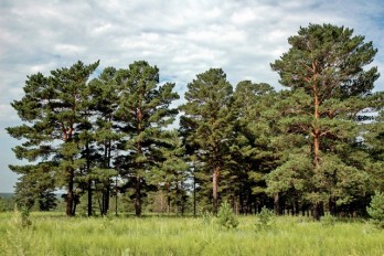
Tsasucheisky Bor State Natural Reserve located in Ononskiy District.
Surface area: 58100 hectares.
It is a reserve of federal importance, includes a unique array of pine forest.
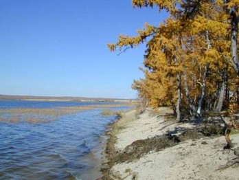
Lakes and other hydrological objects

The section describes the hydrological nature monuments in the territory of Zabaikalsky Krai - Arey, Daurian, Halanda Lakes, mineral springs in the valley Camp and other unique objects.
Gorbunka Lake
Озеро Горбунка
Gorbunka Lake located in Aginskiy District. Surface area: 10 hectares. The depth of the lake is 2.4 m. In the summer, in shallow water can be warmed to 30 °
Borzhigantai Spring Funnel Natural Monument
Боржигантайская родниковая воронка
Borzhigantai Spring Funnel Natural Monument located in Mogoituisky District. Surface area: 1 hectare. The diameter is about 100 m, depth - 10 m.
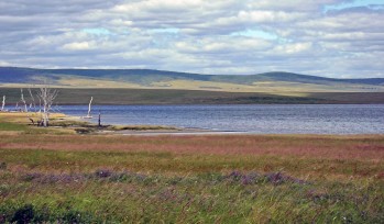
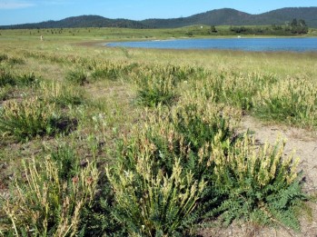
Arei Lake
ОзероАрей
Arei Lake located in Uletovsky District. Surface area: 900 hectares. The lake is located 230 km from Chita. The lake is very popular. Arei`s water is very clean, rich in fish. There are two tourist camps ("Arey" and "Crystal"). Mud have medicinal properties to help with various skin diseases.
Bab'e Lake Natural Monument
Озеро Бабье
Bab'e Lake Natural Monument located in Borzinsky District. Surface area: 112 hectares. Contains significant reserves of medicinal mud.The water depth in Bab`e Lake is very small (5-10 cm).
Barun-Shivertuy Lake
Озеро Барун-Шивертуй
Barun-Shivertuy Lake located in Zabaikalsky District. Surface area: 144 hectares. Barun-Shivertuy in Buryat language means Western (or Right) Mud.
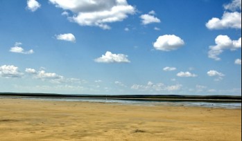
Daurskoe Lake
Озеро Даурское
Daurskoe Lake located in Zabaikalsky District. Surface area: 20 hectares. The lake is located on the path of mass bird migrations in the Daurian steppe.
Doroninskoe Soda Lake
Доронинское содовое озеро
Doroninskoe Soda Lake located in Uletovsky District. Surface area: 950 hectares. The average water depth of about 4 m, maximum - 6.5 m.
Khalanda Lake
Озеро Халанда
Khalanda Lake located in Akshinsky District. Surface area: 112 hectares. Lakeside is well landscaped. There are special places for recreation. On the northern shore Khalanda Lake is a children's camp.
Tsagan-Nor (Mal'tsokskoe) Lake Natural Monument
Озеро Цаган-Нор (Мальцокское)
Tsagan-Nor (Mal'tsokskoe) Lake Natural Monument located in Ononsky District. Surface area: 1125 hectares. Tsagaan-Nor in Buryat means "White Lake". The lake is known for large reserves of medicinal mud, suitable for use in medicine. 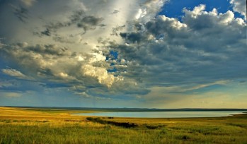
Avdeisky Bulgunniah
Авдейский булгуннях
AvdeiskyBulgunniah located in Chitinsky District. Surface area: 1 hectare. This is a mound with an ice kernel. Its height is about 11, and diameter is about 100 meters.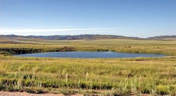
Lagernaya Valley Mineral Spring
Минеральный источник в пади Лагерная
Lagernaya Valley Mineral Spring located in Kirinsky District. Surface area: 1 hectare. Nearby is a children's summer camp "Sun".
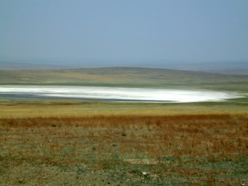
Borzinskoe Sаlt Lake
Борзинское Cоль-озеро
Borzinskoe Sаlt Lake located in Borzinsky District. Surface area: 200 hectares. The lake contains significant reserves of medicinal mud.
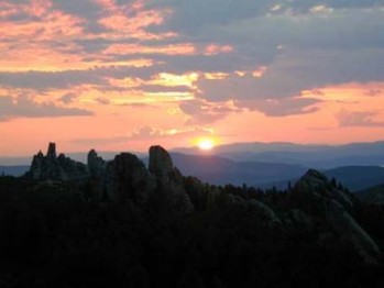
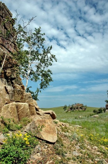
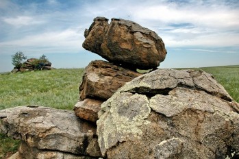
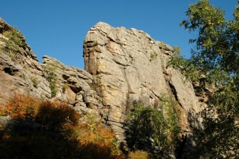
Rocks and mountains
The section describes the geological monuments of nature - rocks and mountain peaks. Presented Alkhanay Temple-Gate Rock, Smolenskie Rocks, the famous Watershed Mountain at the Yablonovy Ridge and other places.
Kadala Palace Rocks
Кадалинские скалы Дворцы
Kadala Palace Rocks located in Chitinsky District. Surface area: 176 hectares. Located near of Chita city and represents one of the favorite places citizens.
Watershed Mountain
Водораздельная гора на Яблоновом хребте
Watershed Mountain located in Chitinsky District. Surface area: 28 hectares. Separates the basins of the three huge rivers of northern Asia.
Maly Bator
Урочище Малый Батор
Maly Bator located in Aginsky District. Surface area: 5 hectares. Located in the Aginskaya Steppe State Reserve. The word "Bator (Baatar)" is translated from Buryat as "hero."
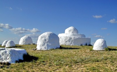
Stony Copper Rock
Скала Камень-Котёл
Stony Copper Rock located in Aginsky District. Surface area: 0,004 hectares. Its known popularly as the "Cup of Genghis Khan". It is one of the objects of worship for the locals.
Alkhanay Temple-Gate Rock
Скалы "Алханайские Ворота"
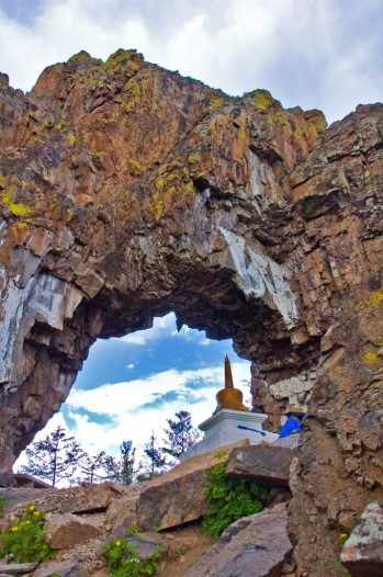
Alkhanay Temple-Gate Rock located in Duldurginsky District. Surface area: 2 hectares. It located within the Alkhanay National Park. Title Alhanayskie Gate, or Gate of the Temple, has received a large rock-outlier, having the shape of the arch.
Stone monuments of Alkhanay
Those who have once visited this unique place created by nature agree that it is earthy heaven. Alkhanay is a mystical place. The gods themselves seem to have descended upon the earth and stood still as stony statutes admiring the people. Rock massifs, healing springs, magnificent wooded lands, wish fulfilment valley, majestic "Temple Gate" and "Mother's Womb" stagger traveller's imagination. The air of Alkhanay is curative and filled with magic. The stars seem to be closer to the earth here and the sun shines much brighter. And maybe it is the case? We recommend to check it out!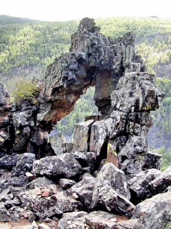
One of the newest national parks of Russia, Alhanay National Park is situated on the territory of AginskyBuryat Autonomous District (Okrug). The central part of the Park is mountainous terrain covered with birch/larch and coniferous forests. The southern sections of the Park are located at lower altitudes and consist primarily of steppe ecosystems. The diversity of habitats and altitudinal zonation allow for the presence of trees that are normally rare in Southeast Transbaikalia such as Siberian pine (cedar pine, Pinussibirica), Pinuspumila and Siberian spruce-tree (Abiessibirica).
The cultural and religious aspects of the Park are equal in importance to the natural riches of Alhanay. The mountain is one of the most esteemed places among the local population and possesses many religious and historic locations connected to a history of the Buryat people. The territory encompassed by Alhanay Park is known for its perfect landscapes, the curative waters of its mountain creeks, and the trails used by religious pilgrims and travelers. Alhanay is one of the most visited places (pleasure and religious) for the people of Transbaikalia with tens of thousands of visitors during the summer season.
The National Park was created for the purpose of preserving valuable landscapes, natural monuments, monuments of history and culture, and flora and fauna. A primary goal is to encourage tourism with minimal impact on the natural landscape and ecosystems. Park officials (administration to rangers) are working hard to provide a friendly and well organized experience for the Park visitors, while minimizing impacts to the natural landscapes due to fires, trash accumulation, and destruction of the top soil.
Alhanay: as part of the history of the Buryat people. A Buryat legend tells about a Balchzhin-hatun princess, who was given in marriage to a Mongolian feudal lord and moved with him and her people to Mongolia. When confronted with the hatred of their enemies, the Balchzhin-hatun princess decided to return home together with her husband and people. Near Alhanay Mountain, their enemies caught up with fugitives and killed the princess. While dying, the princess shouted "alhani" (They are killing); this became the name of the Mountain. The name Balchzhin-hatun is remembered in the name of a nearby lake, Balzinsky Lake, on whose shoreline she was buried. The Buryat people and their descendants have kept a tradition of reverence for Alhanay Mountain, where the history of the people was shaped and a national self-consciousness arose.
Alhanay National Park in the facts and figures:
Established in 1999.
Surface area: 138,2 thousand hectares.
Localization: Duldurginsky District of AginskyBuryat Autonomous District (Okrug).
Highest summit: Alhanay Mountain - 1662 м above a sea level.
Two natural monuments are in the Park: the summit of Alhanay Mountain
and the Temple-Gate Rock.
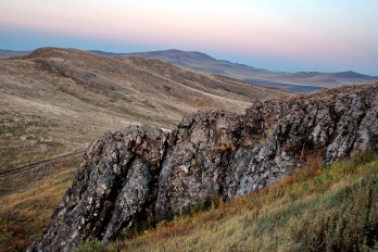
Polosatic (Stripy) Rock
Скала Полосатик
Polosatic (Stripy) Rock located in Sretensky District. Surface area: 32 hectares. The height of the cliff is 60 meters long - more than 1 kilometer.
Smolenskie Rocks
Смоленские скалы
Smolenskie Rocks located in Chitinsky District. Surface area: 16 hectares. It reaches a height of 12-14 meters. It is a popular tourist attraction.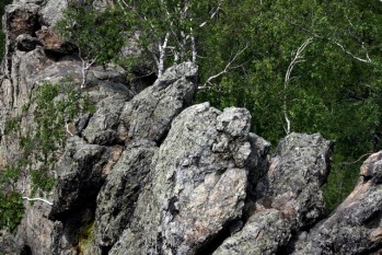
Tsagan-Oluiskie Rocks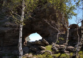
Скалы Цаган-Олуйские
Tsagan-Oluiskie Rocks located in Borzinsky District. Surface area: 120 hectares. Buryat word "Tsagan" translates as "white", "Olui" as a large eagle or vulture.
Alkhanay Mountain
Голец Алханай
Alkhanay Mountain located in Duldurginsky District. Surface area: 5000 hectares. Gore has a height of 1662 m, It located within the Alkhanay National Park.
Saranakan Mountain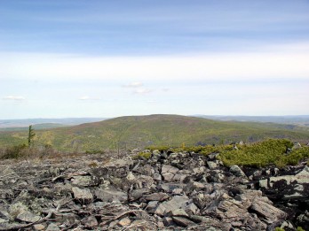
Голец Саранакан
Saranakan Mountain located in Chitinsky District. Surface area: 380 hectares. Represented by two peaks - Big Saranakan (1578 m) and the Small Saranakan (1579 m). Age is 230-245 million years.
Argalituy Mountain
Гора Аргалитуй
Argalituy Mountain located in Krasnokamensky District. Surface area: 228 hectares. Local name of the mountain is Frog. This is one of the vertices Klichkinsky Ridge (907.6 m above sea level).
Birkinskie Rocks
Быркинские скалы
Birkinskie Rocks located in Priargunsky District. Surface area: 48 hectares. Height - 15 m, length - 200 m. It was found drawings of ancient people.
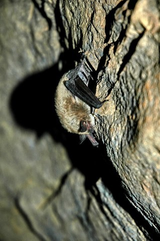
Caves
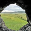
This section contains information about the most unusual caves of ZabaikalskyKrai- Haatei Caves, UrdiukanskyProval Cave, Shilkinskaya Cave, Soktui-Milozanskaya Cave.
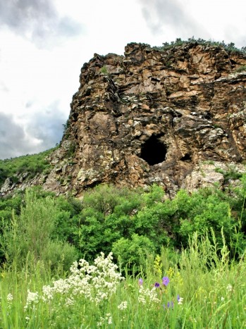
Haatei Caves Natural Monument
Пещеры Хээтэй
Haatei Caves Natural Monument located in Mogoituisky District. Surface area: 3 hectares. Haatey (in Buryat - Patterned) is one of the largest caves in the region. Its total length is 150-160 m.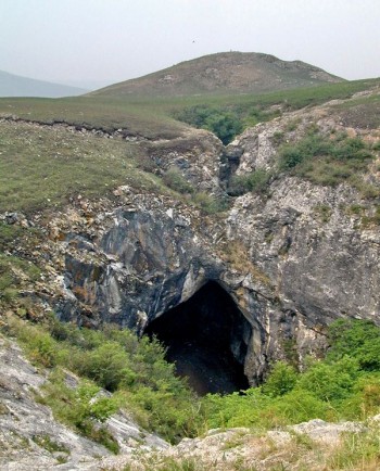
Soktui-Milozanskaya Cave
Соктуй-Милозанская пещера
Soktui-Milozanskaya Cave located in Krasnokamensky District. Surface area: 8 hectares. The air temperature in the cave during the summer lasts about 0 ° C. The total length of the cave rooms is estimated to be 155-160 m.
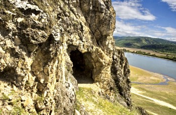
Mangutskaya Cave
Мангутская пещера
Mangutskaya Cave located in Kirinsky District. Surface area: 1 hectare. The cave is located at an altitude of about 13 meters. The entrance to the cave is a surprisingly rounded.
Urdiukansky Proval Cave
Пещера "Урдюканский провал"
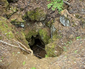
UrdiukanskyProval Cave located in Sretensky District. Surface area: 1 hectare. It located at an altitude of about 580 m above sea level. Water freezes here in the form of bizarre ice sculptures.
Shilkinskaya Cave
Шилкинская пещера
Shilkinskaya Cave located in Sretensky District. Surface area: 1 hectare. Length of the cave is 5.3 m, diameter - about 2.5 m.
Словарь географических названий
-
Daursky State Natural Biosphere Reserve (Zapovednik) Даурский заповедник
-
Projected Chikoy National Park Проектируемый национальный парк "Чикой"
-
Ivano-Arakhleisky State Natural Landscape Reserve (Zakaznik) Ивано-Арахлейский заказник
-
Aginskaya Steppe State Reserve (Zakaznik) Заказник "Агинская степь"
-
Mountain Steppe State Reserve (Zakaznik) Заказник "Горная степь"
-
TsasucheiskyBor State Natural Reserve (Zakaznik) Заказник федерального значения "Цасучейский бор"
-
Gorbunka Lake Озеро Горбунка
-
Borzhigantai Spring Funnel Natural Monument Боржигантайская родниковая воронка
-
Arei Lake Озеро Арей
-
Bab'e Lake Natural Monument Озеро Бабье
-
Barun-Shivertuy Lake Озеро Барун-Шивертуй
-
Daurskoe Lake Озеро Даурское
-
Doroninskoe Soda Lake Доронинское содовое озеро
-
Khalanda Lake Озеро Халанда
-
Tsagan-Nor (Mal'tsokskoe) Lake Natural Monument Озеро Цаган-Нор (Мальцокское)
-
Avdeisky Bulgunniah Авдейский булгуннях
-
Lagernaya Valley Mineral Spring Минеральный источник в пади Лагерная
-
Borzinskoe Solt Lake Борзинское Cоль-озеро
-
Kadala Palace Rocks Кадалинские скалы Дворцы
-
Watershed Mountain Водораздельная гора на Яблоновом хребте
-
Maly Bator Урочище Малый Батор
-
Stony Copper Rock Скала Камень-Котёл
-
Alkhanay Temple-Gate Rock Скалы "Алханайские Ворота"
-
Polosatic (Stripy) Rock Скала Полосатик
-
Smolenskie Rocks Смоленские скалы
-
Tsagan-Oluiskie Rocks Скалы Цаган-Олуйские
-
Alkhanay Mountain Голец Алханай
-
Saranakan Mountain Голец Саранакан
-
Argalituy Mountain Гора Аргалитуй
-
Birkinskie Rocks Быркинские скалы
-
Haatei Caves Natural Monument Пещеры Хээтэй
-
Soktui-Milozanskaya Cave Соктуй-Милозанская пещера
-
Mangutskaya Cave Мангутская пещера
-
Urdiukansky Proval Cave Пещера "Урдюканский провал"
-
Shilkinskaya Cave Шилкинская пещера
Источник: visitchita.ru/en/Places-to-go/Excursions-in-Chita.